
Monday, November 26, 2007

Saturday, November 24, 2007
 This is a side-by-side bivariate map. Kind of hard to find.
http://www.geog.le.ac.uk/russianheartland/DemographicMaps/images/PopulationMaps/RaionMaps/7RaionPopDenPerCh8902.jpg
Wednesday, November 14, 2007
Color map
 Since this lab is being graded on the web, this was the first time when the layout was the main focus. As you can tell from my greyscale map, I never really took the time in trying to fix my layout and I found it to be pretty difficult. As for the color, I find the web version to be quite dull but it may be just the screen. The blues seem to be more similar on the web version but on the printed version each shade of blue really stands out.
Wednesday, November 7, 2007

Sunday, November 4, 2007
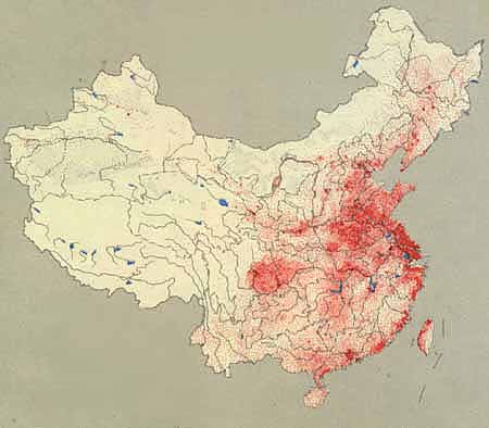
Dot density map of China's population. A dot represents 50,000 people.
Source:http://depts.washington.edu/chinaciv/geo/1zgzpopu.jpg
Wednesday, October 31, 2007

Thursday, October 25, 2007

Wednesday, October 24, 2007


Sunday, October 7, 2007

http://www-groups.dcs.st-and.ac.uk/~history/HistTopics/Cartography.html
Here is an example of a map Eratosthenes would have constructed sometime in the 200's BC. I picked this map because the labels had to be carefully placed to represent proper location.
 oh, we were suppose to post a map with interesting fonts instead of the one I posted on October 1st. Anyway, I picked this map because only pirate maps could fit so many different labels on one map, plus their use of small fonts is always intriguing. And, you don't see scales like this everyday.
http://pirateshold.buccaneersoft.com/images/maps/guinea-map.jpg
Thursday, October 4, 2007

Monday, October 1, 2007

Here is a map of the US but instead of putting in state names, coutries with comparable GDP's are used instead. Amazing.
Thursday, September 27, 2007

Tuesday, September 25, 2007
 http://www.colorado.edu/geography/gcraft/notes/mapproj/mapproj_f.html
I thought this projection was interesting because both the scale and the shape is somewhat distorted, but shows a large country such as the US quite well because its area is accurate across standard parallels.
Thursday, September 20, 2007


Wednesday, September 12, 2007
Websites of Possible Interest
The GIS Development website gives a comprehensive overview on the different applications of GIS. GIS applications range from Urban Planning to Agriculture to Business, and shows just how integral GIS has become in several fields and professions. http://www.gisdevelopment.net/
The need for cartographers is at a all time high around several counties across the country. The Careers in Cartography/GIS website is a good site which explains the procedure to lucrative, and interesting Cartography jobs. http://www.acsm.net/CaGISCareerWeb/index.html
The GIS and Mapping Crime website is an interesting site that details the relationship between crime mapping and cartography. Crime is of some interest to everyone since many decisions we make is affected by it. http://www.ojp.usdoj.gov/ovc/publications/infores/geoinfosys2003/welcome.html
The need for cartographers is at a all time high around several counties across the country. The Careers in Cartography/GIS website is a good site which explains the procedure to lucrative, and interesting Cartography jobs. http://www.acsm.net/CaGISCareerWeb/index.html
The GIS and Mapping Crime website is an interesting site that details the relationship between crime mapping and cartography. Crime is of some interest to everyone since many decisions we make is affected by it. http://www.ojp.usdoj.gov/ovc/publications/infores/geoinfosys2003/welcome.html
Subscribe to:
Posts (Atom)