Wednesday, October 31, 2007
Thursday, October 25, 2007
Wednesday, October 24, 2007
Sunday, October 7, 2007

http://www-groups.dcs.st-and.ac.uk/~history/HistTopics/Cartography.html
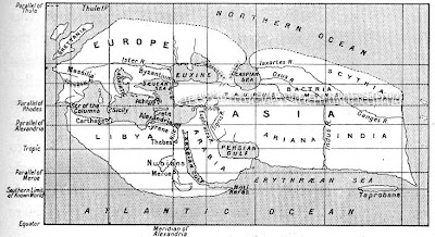
Here is an example of a map Eratosthenes would have constructed sometime in the 200's BC. I picked this map because the labels had to be carefully placed to represent proper location.
 oh, we were suppose to post a map with interesting fonts instead of the one I posted on October 1st. Anyway, I picked this map because only pirate maps could fit so many different labels on one map, plus their use of small fonts is always intriguing. And, you don't see scales like this everyday.
http://pirateshold.buccaneersoft.com/images/maps/guinea-map.jpg
Thursday, October 4, 2007
Monday, October 1, 2007
http://strangemaps.wordpress.com/2007/06/10/131-us-states-renamed-for-countries-with-similar-gdps/
Here is a map of the US but instead of putting in state names, coutries with comparable GDP's are used instead. Amazing.
Here is a map of the US but instead of putting in state names, coutries with comparable GDP's are used instead. Amazing.
Subscribe to:
Comments (Atom)


